Malta is tiny — 27 km long, 14 km wide — but it confuses first-time visitors because everything is close but nothing is where you’d expect. This guide uses the malta map to explain the geography clearly: where the country sits in Europe and the Mediterranean, how the three islands relate to each other, which towns matter for travellers, how far apart everything is, and how to navigate. No fluff, just the map-based information you need before landing.
Where Is Malta on the Map of Europe?
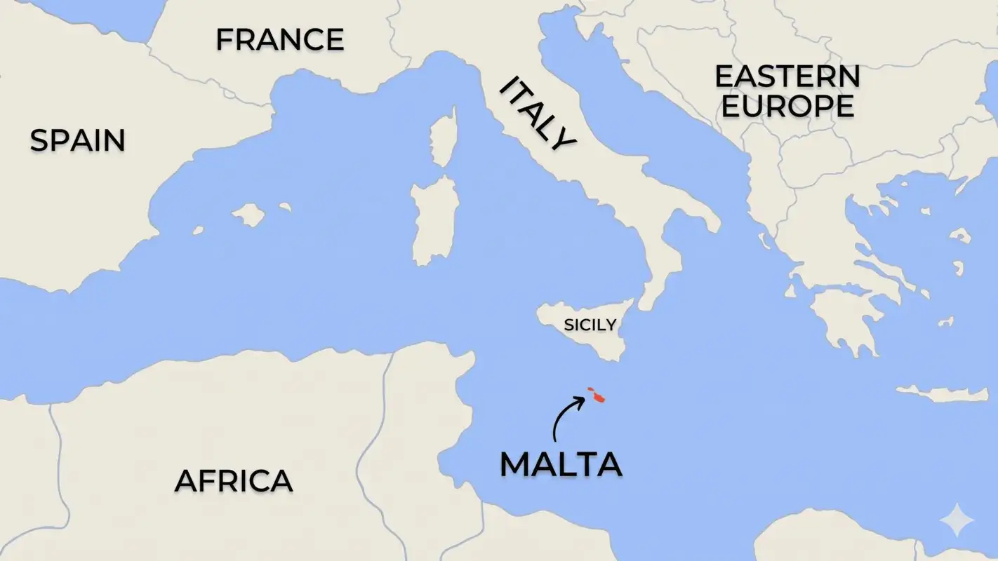
Malta sits in the Mediterranean Sea, 80 km south of Sicily and 280 km north of Libya — the southernmost country in the EU. On a malta map of europe, it appears as a tiny dot below Italy’s boot, closer to North Africa than to Rome. Coordinates: 35.9°N, 14.5°E, squarely in the central Mediterranean between Gibraltar and the Suez Canal shipping lanes.
The location of malta in europe map context matters for understanding the island: it’s a crossroads between three continents, which explains why every major Mediterranean power — Phoenicians, Romans, Arabs, Normans, Knights, French, British — wanted to control it. On a malta map mediterranean, you can see why: it sits directly astride the sea routes between the western and eastern Mediterranean.
Quick geographic facts:
- Total area — 316 km² (smaller than Luxembourg)
- Population — ~550,000 (one of the world’s most densely populated countries)
- Highest point — Ta’ Dmejrek (253 m) near Dingli Cliffs
- Distance from Sicily — 80 km (1h45 by catamaran from Valletta)
- Distance from Libya — 280 km north
The republic of malta map covers three inhabited islands: Malta, Gozo and Comino, with a combined area of 316 km². Despite being the EU’s southernmost and one of its smallest members, it’s a fully independent sovereign state — not part of Italy, not part of Spain — with its own language, government and EU membership since 2004.
The Three Islands — Malta & Gozo Map
Malta isn’t one island — it’s three inhabited islands plus a few uninhabited rocks. On the map of malta and gozo, they sit in a north-south line with short sea crossings between them.
- Malta (the main island) — 246 km², where Valletta, the airport and 95% of hotels are located
- Gozo — 67 km², 25 minutes by ferry from northern Malta. Greener, quieter, more rural. The gozo malta map shows it as roughly 14 km long with Victoria (the capital) at its centre
- Comino — 3.5 km², almost uninhabited, famous for the Blue Lagoon. Day trips only
The malta and gozo map shows two main channels: the Comino Channel between Malta and Comino, and the Gozo Channel between Comino and Gozo. Ferries cross both year-round from Ċirkewwa in northern Malta. The entire island chain from southern Malta to northern Gozo spans roughly 45 km.
Malta Tourist Map — Main Towns & Areas
The malta tourist map that matters for planning centres on six zones. Understanding which area does what saves a lot of confusion when booking accommodation.
Valletta & the Grand Harbour
The capital, sitting on a tiny peninsula on the central-east coast. The valletta map malta shows it as a walkable grid — end-to-end in 20 minutes on foot. UNESCO World Heritage Site, 16th-century Baroque city built by the Knights of St John, 8 km from the airport. Ferry terminals connect to Sliema (15 min) and the Three Cities (10 min) across the harbour.
Sliema & St Julian’s
The main tourist strip, immediately north of Valletta on the east coast — a continuous 3 km of hotels, restaurants and seafront promenades. On the sliema malta map you can see how the two towns merge without any visible gap. St Julian’s contains Paceville, the main nightlife district. Most first-time visitors base themselves here.
Mellieħa & the North
The northern tip of the main island: Malta’s biggest sandy beach at Mellieħa Bay, the Ċirkewwa ferry port for Gozo, and the west coast beaches of Golden Bay and Għajn Tuffieħa. The malta beaches map shows the north concentrating most of the sandy beaches — the south and east are mostly rocky coves and limestone platforms.
Mdina & Rabat (Centre)
Inland, roughly in the middle of the island. Mdina is the medieval walled capital before Valletta — the “silent city.” On the malta country map, Mdina sits almost exactly at the geographic centre, making it easy to combine with other areas in a single day trip.
Marsaxlokk & the South
Southern Malta — the traditional fishing village of Marsaxlokk with its Sunday fish market, the Blue Grotto sea caves, the prehistoric temples of Ħaġar Qim and Mnajdra, and the Dingli Cliffs. Less touristy, more scenic, genuinely beautiful drives.
The Three Cities
Birgu (Vittoriosa), Senglea and Cospicua — the three historic towns across Grand Harbour from Valletta. Quieter and more authentic, reachable by ferry in 10 minutes. Home to Fort St Angelo and the Inquisitor’s Palace.
Gozo Island Map
Cross the 25-minute ferry from Ċirkewwa and you arrive at Mġarr harbour on Gozo’s southern tip. The map of gozo malta is compact — everything is within 20 minutes by car. Key points on the gozo island malta map:
- Victoria (Ir-Rabat) — the capital at the island’s centre, with the Citadel fortress above
- Xlendi & Marsalforn — the two main coastal resort villages, with rocky swimming and seafood
- Dwejra — west coast, site of the former Azure Window, Inland Sea and Fungus Rock
- Ramla Bay — north coast, Gozo’s famous red-sand beach
- Ġgantija Temples (Xagħra) — megalithic temples from 3,600 BC, older than the pyramids
Most visitors do Gozo as a day trip from Malta, but staying 1-2 nights gives you the island to yourself in the evenings — genuinely worth it.
Malta Bus Map & Getting Around
The malta bus map covers the entire main island with routes radiating from Valletta Central Bus Station. A few important things to know:
- All routes go through Valletta — to get from Sliema to Marsaxlokk, for example, you change buses there
- The malta bus routes map covers all major tourist areas including Mellieħa, Marsaxlokk, Mdina and the airport
- Gozo has its own separate network from Mġarr harbour
- Some rural areas (Gnejna Bay, Fomm ir-Rih) aren’t on the network — a car or taxi is needed
- Express routes X1, X2, X3 connect the airport to Valletta and Sliema quickly
The Tallinja app shows real-time arrivals and the complete bus route map for Malta. Every stop has a QR code for live times. The full malta bus network map is also downloadable from the Malta Public Transport website.
Malta Beaches Map
Sandy beaches are concentrated in the north and northwest of the main island; rocky limestone swimming spots are everywhere else. Key spots on the malta beaches map:
- Mellieħa Bay — Malta’s largest sandy beach, north coast, family-friendly
- Golden Bay — northwest, beautiful golden sand, lifeguarded, arrive early in summer
- Għajn Tuffieħa — next cove south of Golden Bay, fewer crowds, 200 steps down
- Blue Lagoon (Comino) — best snorkelling water, packed July-August, boat trip required
- Ramla Bay (Gozo) — red sand, the best beach on Gozo
Distances & Travel Times
Nothing is far on the malta maps — you can drive across the main island in under an hour.
| From | To | Distance | Car | Bus |
|---|---|---|---|---|
| Airport | Valletta | 8 km | 15-20 min | 30-40 min |
| Valletta | Sliema | 4 km | 10-15 min | 20 min (+ ferry 10 min) |
| Sliema | St Julian’s | 2 km | 5-8 min | walkable / 15 min bus |
| Valletta | Mdina | 10 km | 20 min | 40 min |
| Sliema | Mellieħa | 20 km | 30 min | 60 min |
| Sliema | Ċirkewwa (Gozo ferry) | 25 km | 40 min | 75 min |
| Ċirkewwa | Mġarr (Gozo) | sea crossing | 25 min (ferry) | 25 min (ferry) |
| Airport | Marsaxlokk | 7 km | 15 min | 30 min |
Driving times increase 30-50% during summer rush hour (8-9 AM, 5-7 PM). For anywhere off the main bus routes, a rental car saves real time.
Google Maps Malta & Navigation Apps
Google maps malta coverage is essentially perfect across both main islands — bus routes, ferry schedules and real-time traffic all included. Download the offline map before landing for backup on Gozo and Comino where signal occasionally drops. The malta google map on desktop is also useful for planning routes before you arrive.
Other useful options: Maps.me for offline maps including Gozo hiking trails, the Tallinja app for real-time bus arrivals, and the official Gozo Ferry app for crossing timetables.
Our complete Malta holidays guide shows how to split your days. For activities in each zone, browse our Malta activities directory.
FAQ — Malta Map
Where is Malta on the map?
In the Mediterranean Sea, 80 km south of Sicily and 280 km north of Libya. It’s the EU’s southernmost country, sitting between Italy and Tunisia — closer to Africa than to Rome.
Is Malta part of Italy?
No. Malta is a fully independent sovereign state since 1964 — its own country, language and government. It’s close to Sicily (80 km) and shares some cultural influence, but is completely separate politically and legally.
Is Malta part of Spain?
No. Malta has no political connection to Spain. It was under Aragonese rule in the medieval period, which left some cultural traces, but has been independent since 1964.
Is Malta in the EU?
Yes. Malta joined the European Union in 2004, adopted the Euro in 2008, and is part of the Schengen Area. Geographically closer to Africa, but politically and legally fully European.
How big is Malta?
316 km² total across the three islands. The main island is 246 km² — you can drive across it in under an hour. The republic of malta map covers all three: Malta, Gozo (67 km²) and Comino (3.5 km²).
How do I get from Malta to Gozo?
Ferry from Ċirkewwa in northern Malta to Mġarr on Gozo — runs every 45 minutes, 25-minute crossing, around €4.65 return for foot passengers. Clearly shown on any map of malta and gozo.
Where can I find a Malta bus map?
The malta bus map is available on the Malta Public Transport website, the Tallinja app, and at the Valletta bus terminus. Every stop has a QR code for live arrivals.
What’s the best app for navigating Malta?
Google Maps works excellently across both main islands including bus routes and real-time traffic. Download it offline before visiting Gozo or Comino where 4G can occasionally drop.
Is Malta walkable?
Within individual towns, yes. Valletta, Mdina, Sliema and St Julian’s are all walkable end-to-end. Between towns it’s mostly bus, taxi or car — though Sliema to St Julian’s is a pleasant 2 km seafront walk.
→ Got your geography sorted? Plan the full trip with our complete Malta holidays guide